Discover Norway’s second-largest island, where jagged peaks, white-sand beaches, fishing villages and coastal roads combine to create one of Northern Norway’s most memorable travel experiences.
Senja is often described as “Norway in miniature”, and for once the nickname feels justified.
Within a relatively compact area, you’ll find steep mountains plunging into the sea, sheltered fjords, pine forests, fishing communities, sandy beaches and open Arctic horizons.
For many international travellers, Senja still sits in the shadow of better-known names. Tromsø draws the northern lights crowds. Lofoten gets the magazine covers. Vesterålen attracts whale watchers and road trippers.
Senja, sandwiched between them, is sometimes treated as a place to pass through. That would be a mistake.
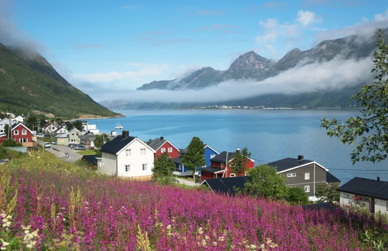
Senja offers some of the drama associated with Lofoten, but with a different feel. It is less polished, less busy, and in places far more rugged. The roads are narrower, the weather feels closer, and the settlements cling to the landscape in a way that reminds you this is not a theme park. People live and work here.
However you visit, Senja rewards time, flexibility and a willingness to let the weather set the pace. Let's take a closer look!
Where Is Senja?
Senja lies in Troms, north of the Arctic Circle, between Tromsø and the Vesterålen archipelago. It is Norway’s second-largest island, although Senja municipality also includes mainland areas and smaller surrounding islands.
The municipal centre is Finnsnes, which sits on the mainland side of the Gisund Bridge. Cross the bridge and you are on Senja itself.
The island’s eastern side is the most practical arrival point, with road connections, services and access to Finnsnes. The west and north are where most visitors focus their time, thanks to the dramatic coastal scenery, fishing villages, beaches and viewpoints along the National Scenic Route.
Why Visit Senja?
The simple answer is scenery. Senja’s northern and western coasts deliver some of the most striking landscapes in Northern Norway.
Mountains rise abruptly from the sea. Narrow fjords cut deep into the island. Small villages sit squeezed between cliffs and water. White-sand beaches appear unexpectedly between dark rock and turquoise shallows.
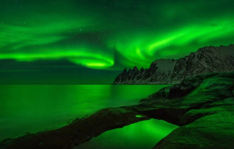
On a clear summer evening, the midnight sun can turn the whole coast gold. In winter, the same roads feel wilder, with snow-covered peaks and the possibility of the northern lights overhead.
But Senja is not just a place for photographers. It is also a practical alternative or addition to better-known Arctic destinations.
From Tromsø, it can be reached by road, ferry and seasonal transport routes. From Gryllefjord, a summer ferry links Senja with Andenes in Vesterålen, making the island a natural stop on a longer Northern Norway itinerary.
Most of all, Senja still feels like somewhere with room to breathe. It is popular with Norwegian travellers and increasingly known internationally, but it has not lost its working coastal character.
Drive The National Scenic Route Senja
For most first-time visitors, the best introduction to Senja is the National Scenic Route. The official route runs for 102km between Botnhamn in the north and Gryllefjord in the west, with worthwhile detours to villages such as Husøy, Mefjordvær and Bøvær.
This is one of Norway’s 18 National Scenic Routes, a collection of roads chosen not simply for getting from A to B, but for the experience of the journey itself. On Senja, that experience is all about the meeting point between ocean, fjords and mountains.
You should not rush it. On paper, the distance looks manageable. In reality, the road invites constant stops. The weather changes quickly, the light shifts from minute to minute, and many of the best views appear suddenly around bends in the road.
A full day is the minimum if you want to drive the route properly. Two or three days is much better, especially if you want to include short walks, photography stops, cafés, beaches or detours.
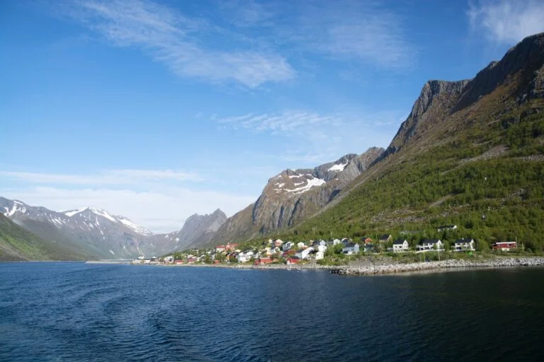
Husøy: A Fishing Village In The Fjord
Husøy is one of Senja’s most memorable settlements. The village sits on a small island in the Øyfjord, surrounded by steep mountains and exposed to fierce Arctic weather.
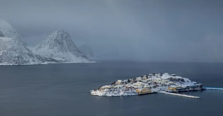
From a distance, it looks almost improbable. Houses, harbour buildings and fish industry infrastructure are packed tightly together, connected to the rest of Senja by a causeway. This is not a preserved museum village. Husøy remains an active fishing community, which is part of its appeal.
The detour to Husøy is especially worthwhile if you want a sense of how people live in these dramatic coastal landscapes. The views are superb, but so too is the reminder that beauty and practicality are closely linked in Northern Norway.
Mefjordvær And Senjahopen
Mefjordvær is another small fishing village worth the short detour from the main route. It sits near the mouth of the Mefjord, with open sea, mountains and harbour views all around.
The breakwater is a good place to stretch your legs (bear in mind recent storm damage), take photographs and get a feel for the coast. Nearby Senjahopen has more services and is one of the more important settlements on this part of the island.
This stretch of Senja is a good example of why the island rewards slower travel. The individual stops may not take long, but together they build a picture of a working Arctic coast shaped by fish, weather and geography.
Ersfjordstranda: Senja’s Arctic Beach
Northern Norway is full of beaches that look tropical until you remember where you are. Ersfjordstranda is one of Senja’s best-known examples.
The sand is pale, the water can appear bright turquoise, and the surrounding mountains give the beach a dramatic backdrop. On a calm summer day, it is an outstanding picnic stop. In rougher weather, it becomes a place to watch the Arctic coast at work.
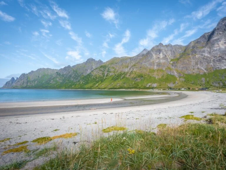
Swimming is possible, but the water is cold even in summer. For most visitors, Ersfjordstranda is less about sunbathing and more about the surreal combination of beach scenery and Arctic setting.
The beach is also known for its architect-designed golden toilet building, one of those small but memorable details that often appear along Norway’s scenic routes.
Tungeneset And The Devil’s Jaw
If you have seen one dramatic photograph of Senja, there is a good chance it was taken at Tungeneset.
This rest area is famous for its view across the water to the jagged Okshornan peaks, often nicknamed the Devil’s Jaw. The mountains look impressive in clear weather, but they can be even more atmospheric when clouds cling to the summits or rain sweeps across the fjord.
A wooden walkway leads from the parking area across the rocks towards the shoreline. It is a simple intervention, but an effective one, giving visitors a safe and satisfying way to move closer to the view.
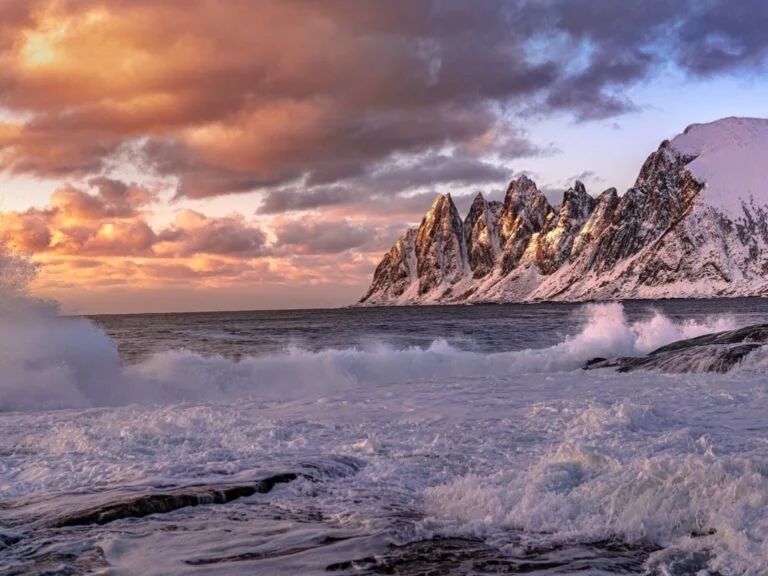
Photographers often linger here for good reason. The scene changes constantly with the light, tide and weather.
Bergsbotn Viewpoint
As the road climbs, the perspective changes. At Bergsbotn, a 44-metre viewing platform extends out over the landscape, offering a broad view across Bergsfjorden and the surrounding mountains.
It is one of the best examples of the National Scenic Routes approach: architecture used not to dominate the landscape, but to sharpen your experience of it.
The road around this part of Senja can be narrow and winding, so take your time. Cyclists also use the route, which forms part of Norway’s long coastal cycling network.
Gryllefjord And The Link To Vesterålen
The scenic route ends at Gryllefjord, a fishing village on Senja’s west coast. It is a worthwhile stop in its own right, but for many travellers it also serves a practical purpose.
In summer, the car ferry between Gryllefjord and Andenes connects Senja with Vesterålen. This makes it possible to build a spectacular overland route from Tromsø through Senja and onwards towards Vesterålen and Lofoten.
The ferry is seasonal and popular. In the main summer season, especially with a car or campervan, you should check current timetables and allow extra time. Queues can build on busy days.
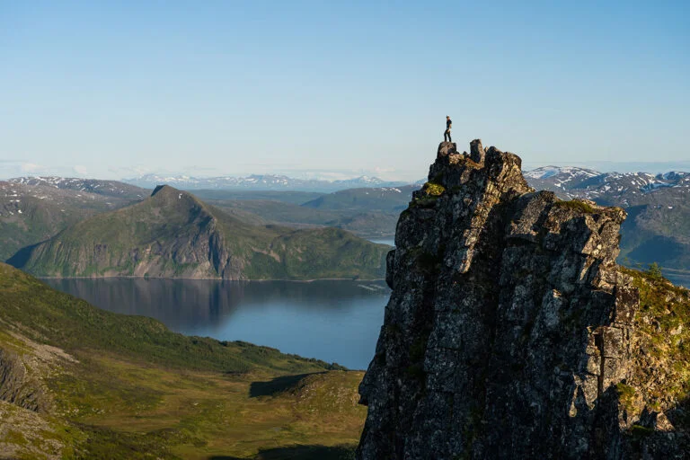
Senja has become increasingly popular with hikers, and it is easy to see why. The island’s mountains are close to the sea, which means even relatively short hikes can deliver huge views.
Segla is the island’s most famous mountain, but many of the classic photos of Segla are actually taken from nearby Hesten. Both hikes start near Fjordgård and should be treated as proper mountain hikes, not casual viewpoints. Trails can be steep, exposed and slippery, and snow can linger or return outside the short summer season.
Husfjellet is another popular option, with views towards the Ersfjord, Bergsfjord and the sharp peaks of the north-west coast. It is often described as a more manageable hike than some of Senja’s steeper summit routes, although conditions can still make a big difference.
As always in Norway, choose hikes based on the weather, your fitness and your experience. A clear day on Senja can be unforgettable. A windy, wet day on exposed terrain can be something else entirely.
Ånderdalen National Park
Senja is not only about coastal drama. In the southern part of the island, Ånderdalen National Park protects a quieter, wilder landscape of old pine forest, birch woodland, rivers, lakes, mountains and coastal nature.
This is a different side of Senja. Instead of roadside viewpoints and famous peaks, Ånderdalen offers a deeper sense of wilderness. It is a good choice if you want to escape the busier scenic route and experience the island’s inland landscapes.
There is a relatively accessible entry point at Tranøybotn, where a universally designed trail leads towards the national park boundary. From there, longer and rougher routes continue into more remote terrain.
Senja In Summer
Summer is the easiest season for a first visit to Senja. The days are long, the roads are generally more straightforward, and the seasonal ferry to Andenes opens up excellent itinerary options.
This is also the main hiking season. Even so, summer in Arctic Norway does not guarantee warm or settled weather. You may experience sunshine, fog, wind and rain in the same day. Pack layers, waterproofs and patience.
The midnight sun season brings extended daylight, which is ideal for photography and flexible road trips. It also means you can visit popular viewpoints early or late in the day, when the light is often better and the roads are quieter.
Senja In Winter
Winter transforms Senja. Snow softens the mountains, the villages feel more remote, and the dark season brings the possibility of northern lights.
However, winter travel on Senja requires more planning. Roads can be narrow, icy and affected by storms. Daylight is limited for part of the season, and some services operate reduced hours. If you are not confident driving in winter conditions, consider guided tours or base yourself somewhere that can help arrange activities.
The reward is atmosphere. Senja in winter feels raw and powerful, with a sense of Arctic isolation that is harder to find in busier destinations.
How To Get To Senja
The most flexible way to visit Senja is by car. You can drive from Tromsø to Finnsnes and cross the Gisund Bridge onto the island. Depending on your route and stops, the drive from Tromsø to the northern and western parts of Senja takes several hours.
Another scenic option from the Tromsø side is the ferry between Brensholmen on Kvaløya and Botnhamn on Senja. This works especially well as part of a circular road trip, but you must check current timetables before setting off.
Public transport exists, but it is limited and requires planning. Express boats connect Tromsø with Finnsnes and some Senja locations on selected routes, while buses serve parts of the island.
Seasonal bus and ferry combinations have also made it easier to travel between Tromsø, Senja, Vesterålen and Lofoten without a car, but schedules change and should always be checked close to travel.
The nearest airport is Bardufoss, around 45 minutes by road from Finnsnes. Tromsø and Harstad/Narvik Airport at Evenes are also realistic options, especially if you plan to rent a car.
Where To Stay On Senja
Accommodation on Senja ranges from hotels and lodges to cabins, guesthouses and campsites. Options are spread around the island, so where you stay will shape your trip.
Finnsnes and Silsand are practical choices if you want services and transport connections. Mefjordvær, Hamn, Skaland, Torsken and other coastal bases place you closer to the dramatic western and northern scenery.
If your main goal is photography, hiking or the scenic route, staying on the outer coast will reduce driving time. If you are visiting in winter, consider accommodation that offers meals, local advice or organised activities, as services can be more limited than you might expect.
Practical Tips For Visiting Senja
Senja is not a place to plan too tightly. Distances can look short on a map, but narrow roads, weather, ferry schedules and photo stops all slow things down.
Fuel, food shops and restaurants are limited in some areas, especially away from Finnsnes and the larger settlements. Do not assume you can find everything you need along the scenic route. Fill the tank, carry snacks, and check opening hours.
Mobile coverage is generally good in many populated areas, but it is still wise to download maps before heading into more remote parts of the island. Weather forecasts are essential, particularly if you plan to hike.
Wild camping and campervan travel are popular in Northern Norway, but pressure on small communities and scenic locations has increased. Use designated facilities where available, respect local signs, and remember that the right to roam comes with responsibilities.

Hi, it’s my first time to comment ☺
I get excited in this post coz this is the place of my Norwegian boyfriend. Hopefully I’ll be able to get there next month if I get my visa 🤞
Can you provide some information on the accommodations on the Senja Island, such as Airbnb, VRBO, Lodges, besides campground? I have been planning a hiking trip (All epic trails) on Senja and Lofoten Islands for 2023. Thanks.
Lots of midges/black fly?
I don’t think so Jane.
I think that it might be a bit too chilly the little flies -or not??
I do not recall those little ‘biters’ while I grew up in Vesterålen, at any time.
However, there are A LOT of mosquitos ALL the time!
A Norwegian-American.
Randi
The F862 Svartholla (west of Mefjordbotn) in Senja is closed to all traffic, cyclists & pedestrians due to ongoing roadworks, which are estimated to be complete 1/11/2022.
Links: https://www.vegvesen.no/trafikk/#/ruteplanlegger?lat=69.33309&lng=17.29043&zoom=8&layer=fer,tra,ctv,tfl
https://www.tffk.no/tjenester/samferdsel/fylkesvei/veiprosjekter/fv-862-skredoverbygg-svartholla/
So at the moment the scenic round trip cannot be made in one circuit. Access to the eastern or western legs must be chosen after crossing the Finnsnes – Silsand bridge.
I have verified today (23/08/2022) that the work is still in progress, but fortunately I’m here for a week before driving down to Lofoten.
Thanks for the update!
No problems. I have enjoyed reading your articles for years …… please keep ’em coming ! Being retired, my partner and I usually have two month-long explorations into our favourite country, and value the information you impart.
Is the ferry between andenes and gryllefjord working even in case of bad weather conditions? Is possible that that the company cancel the trip?
Thank you
I’ve looked for the bus timetables in Senja on the internet and I saw they do exist, but they are quite poot. Are they improved during summer season?