Somewhere in the misty stretch of sea between mainland Norway and Svalbard lies a place few people will ever see, and even fewer will ever set foot on. Bjørnøya, or Bear Island, is one of the country’s most remote and least understood outposts.
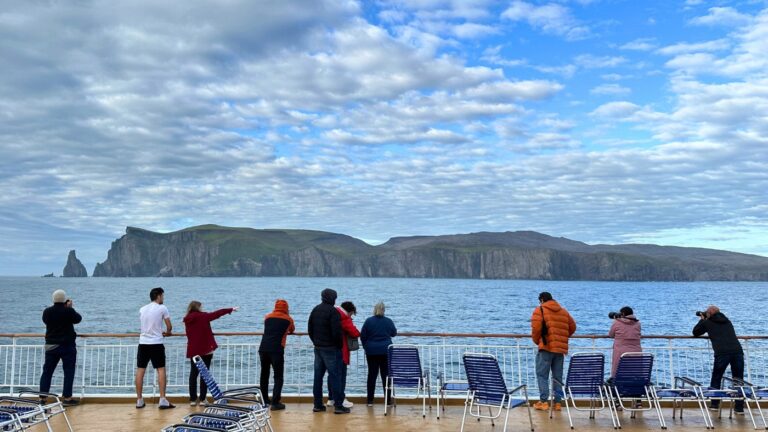
I’ve sailed the route between Northern Norway and Svalbard several times now, and each journey has brought me within range of this lonely island.
On two occasions, the fog was so thick we couldn’t see anything at all. It was only the sudden flurry of seabirds that hinted land was near.
But once, while travelling on Hurtigruten’s Svalbard Line aboard the MS Trollfjord, I was lucky. The weather cleared just enough for us to glimpse the island up close.
I happened to be on the bridge that day, filming one of my YouTube port pronunciation videos with a navigation officer.
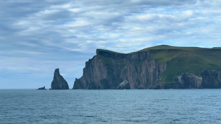
From that lofty viewpoint, I watched as Bjørnøya slowly took shape on the horizon with jagged cliffs, grey sky, and an eerie silence broken only by the sea and the birds.
Despite its name (Bjørnøya means Bear Island in English), there are no polar bears on Bear Island. Instead, Bjørnøya offers a fascinating mix of rugged geology, rich birdlife, Cold War secrets, and extreme solitude.
Officially part of the Svalbard archipelago, the island has no permanent population. There's only a small crew running a weather station, cut off from the rest of the world by thousands of kilometres of ocean.
Where Is Bjørnøya?
Bjørnøya sits in the Barents Sea, roughly halfway between Tromsø and Longyearbyen. Although it is officially part of the Svalbard archipelago, it feels very much like its own isolated world. The nearest land in any direction is several hundred kilometres away.
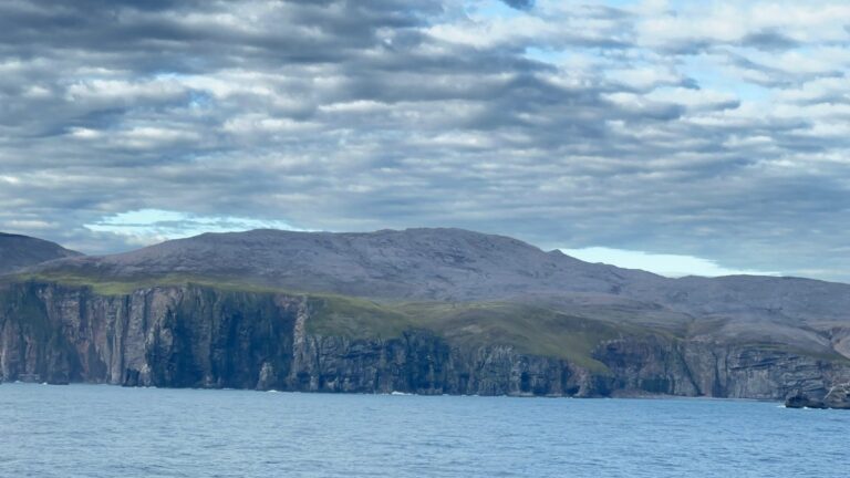
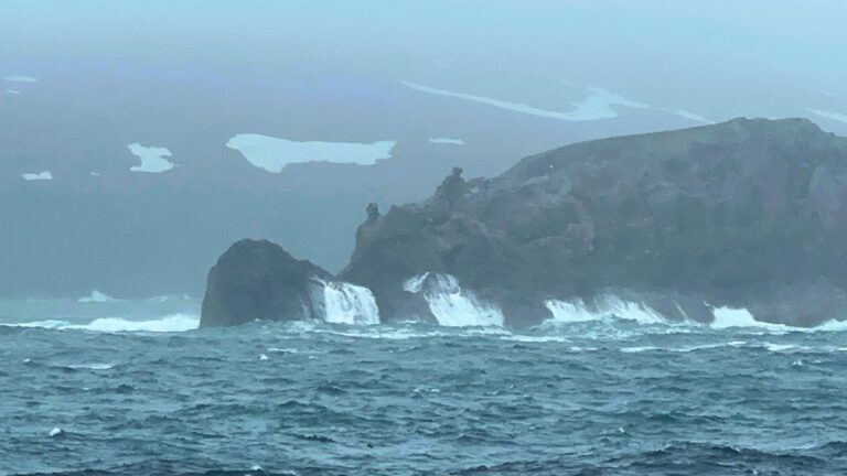
The island covers an area of about 178 square kilometres, making it small in size but significant in strategic and environmental terms. Its coastline is steep and dramatic, with towering cliffs on the southern side and more accessible lowlands to the north, where the weather station is located.
Despite its position far north of the Arctic Circle, Bjørnøya is not always covered in snow. The island’s location in the path of warmer ocean currents gives it a milder, wetter climate than much of Svalbard.
Dense fog, strong winds, and rapidly changing weather are more common than ice and snow for much of the year.
Few ships pass close to Bjørnøya, and even fewer make landfall. For those lucky enough to glimpse it through the fog, the island can seem otherworldly: a dark silhouette rising from the sea, home to thousands of seabirds and just a handful of people at any one time.
Why Is It Called Bear Island?
The name Bjørnøya, or Bear Island, dates back to the year 1596, when Dutch explorers Willem Barentsz and Jacob van Heemskerck spotted the island during an Arctic expedition.
According to their accounts, they saw a polar bear swimming nearby and decided to name the island after it. The bear, however, was simply passing through.
There is no permanent polar bear population on Bjørnøya. While they do occasionally drift south from Svalbard on floating ice, such visits are very rare. The island is not considered part of the polar bear's natural habitat, and people stationed there are not required to carry rifles for protection, which is standard practice farther north.
Despite this, the name has remained in use for more than 400 years. Many people still assume the island is home to Arctic wildlife similar to that found in Svalbard. In reality, Bjørnøya has a much milder climate and a very different ecosystem. The most dominant life here is not the bear, but the bird.
A History of Exploration and Exploitation
Bjørnøya has long attracted the attention of explorers, hunters, and governments, although few people have ever lived there for any length of time.
After the island was sighted in 1596, Dutch and English whalers were among the first to return. Throughout the 17th and 18th centuries, they hunted the surrounding waters for whales and walrus. The island itself was used as a temporary base during the summer months.
Today, remnants of those early expeditions remain scattered across the landscape, slowly being reclaimed by moss and time.
In the early 20th century, several companies attempted to mine coal on the island. Although small deposits were found, the harsh conditions, frequent fog, and lack of a proper harbour made commercial extraction unworkable. Each venture was short-lived.
During the Second World War, Bjørnøya became strategically important due to its location between mainland Norway and Svalbard. The island's weather station provided valuable data to the Allies as they navigated Arctic shipping routes.
German forces tried to disrupt operations, and the Norwegian presence on the island continued under difficult conditions throughout the war.
Since the 1940s, Bjørnøya has served primarily as a site for scientific and meteorological monitoring. While no one lives there permanently, the island has been continuously staffed by rotating crews since 1947.
What remains today are traces of those earlier attempts to claim and use the island. Rusted machinery, abandoned equipment, and the foundations of old buildings tell the story of a place that has always been difficult to tame.
Bjørnøya Weather Station
Today, the only human presence on Bjørnøya is found at the weather station on the island’s northern coast. Operated by the Norwegian Meteorological Institute, it has been staffed year-round since 1947.
Each year, two crews of around nine or ten people rotate in and out, typically serving for six months at a time. The team usually includes meteorologists, technicians, engineers, a station manager, and a cook.
Their main responsibility is to maintain continuous weather observations, which are crucial for Arctic forecasting and climate research.
Life at the station is quiet and deeply isolated. With no harbour, supplies must be delivered by helicopter or dropped by boat when conditions allow. There is a short airstrip used only in emergencies or by military aircraft, but most travel to and from the island depends on the weather.
Despite the remoteness, the station is relatively well equipped. Staff live in shared housing, with common areas for meals and recreation. Internet access is limited but sufficient for communication. Outside working hours are often spent reading, walking, watching films, or simply enjoying the rare peace and silence that Bjørnøya offers.
While storms, fog, and darkness are part of daily life, so is a strong sense of community. For those who take on a posting at Bjørnøya, the experience is often described as both challenging and unforgettable.
Nature and Wildlife
Although treeless and windswept, Bjørnøya is rich in wildlife, especially seabirds. The island is one of Norway’s most important bird sanctuaries, home to millions of nesting birds during the summer months.
Species include puffins, guillemots, kittiwakes, and fulmars, which thrive on the island’s steep cliffs and rocky coastlines.
The land itself is covered in moss, lichen, and hardy Arctic plants. There are a few freshwater lakes and wetlands that support limited biodiversity. Arctic foxes and seals are more occasionally seen along the shores.
Strict environmental protections are in place, and most of the island is off-limits without special permission. This isolation has helped preserve Bjørnøya’s fragile ecosystem.
Access and Restrictions
Bjørnøya is not open to the public. There are no scheduled transport links, and landing is only permitted with special authorisation from Norwegian authorities.
The island has no harbour, and rough seas often make landings by boat impossible. Helicopters occasionally deliver supplies or transport staff, but only in suitable weather.
While some regular cruise ships on their way to Svalbard and expedition cruises pass nearby, passengers rarely set foot on the island. Even scientific and government visits are limited and carefully regulated to protect the environment and ensure safety.
Bear Island in Popular Culture
Bjørnøya may be little known in real life, but it did gain wider attention through the 1971 novel Bear Island by British author Alistair MacLean.
The book, a thriller set on a fictionalised version of the island, follows a film crew whose trip turns deadly as secrets from the Second World War resurface.
Although MacLean took creative liberties with the geography and history, the novel helped cement Bjørnøya’s place in popular imagination. It was later adapted into a film in 1979, further adding to the island’s mystique as a remote, dramatic, and dangerous place far from the familiar.
Why Bjørnøya Matters
Bjørnøya may seem like a lonely rock in the sea, but it holds quiet importance for Norway. Its weather station plays a key role in Arctic forecasting and contributes to long-term climate research.
The island also has strategic value, extending Norway’s presence in the Barents Sea and reinforcing its role in managing and protecting Arctic territories.
For those who pass by at sea, Bjørnøya is a place of mystery. Hidden in fog, surrounded by birds, and rarely seen up close, it reminds us that even in the modern world, some parts of Norway remain truly wild and out of reach.