Tall mountains, wild reindeer, and one of Norway’s most scenic road trips await visitors to Rondane National Park. This is a quieter, more contemplative mountain landscape, and one that rewards those who take their time.
Rondane does not shout for attention. There are no famous cliff hikes, no viral viewpoints, and no single landmark that dominates postcards.
Yet many Norwegians return here year after year, drawn by something harder to define. The wide valleys, gently rising peaks, and open plateaus create a sense of space and calm that feels distinctly Norwegian.
As Norway’s first national park, Rondane occupies a special place in the country’s relationship with nature. It is a landscape shaped not just by ice and time, but by ideas of conservation, solitude, and respect for wildlife.
For hikers, drivers, artists, and anyone seeking a quieter mountain experience, Rondane offers something rare.
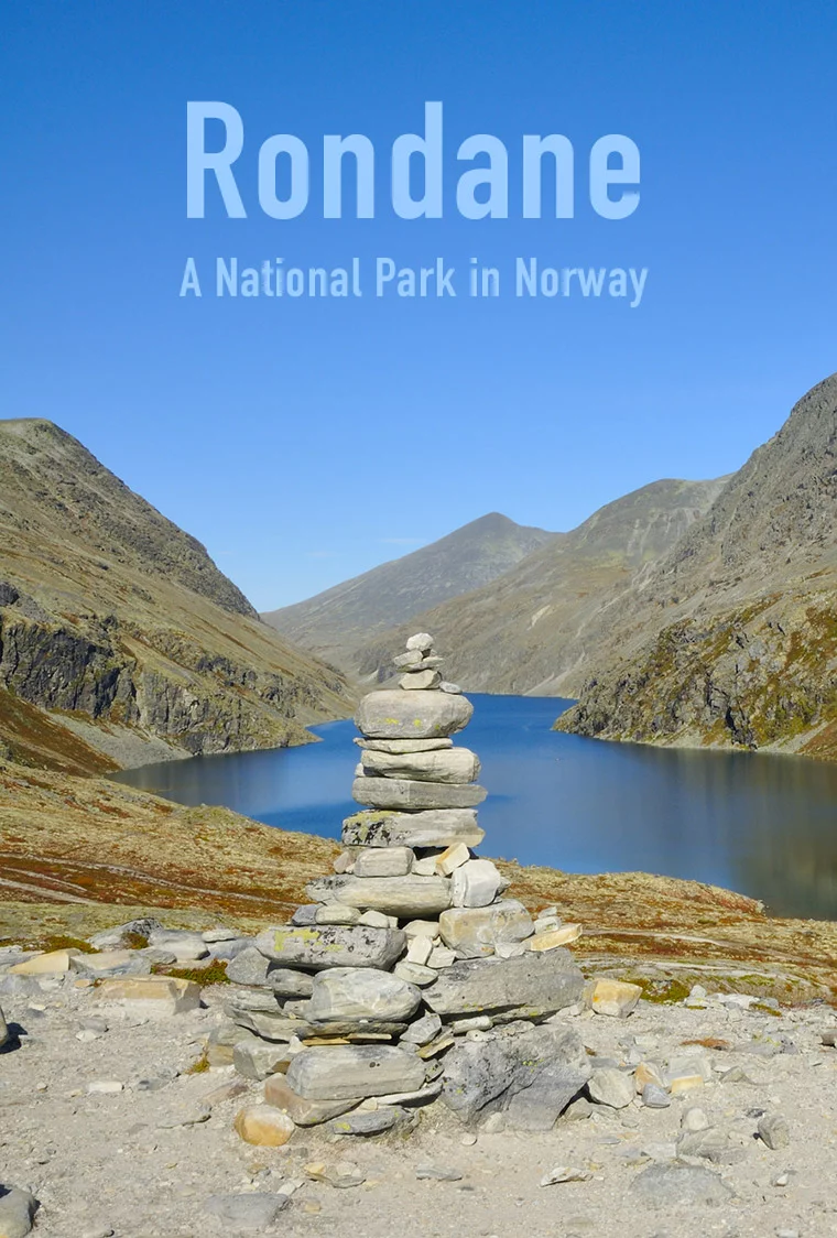
Introducing Rondane National Park
Established in 1962, Rondane National Park was Norway’s first national park, a decision that reflected growing awareness of the need to protect large, connected mountain landscapes.
Today, the park covers an area of high plateaus, rounded peaks, lakes, and glacial features spread across Innlandet county.
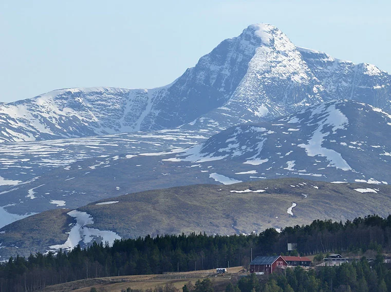
The terrain is mountainous, though not sharply dramatic in the way of Jotunheimen. Ten peaks rise above 2,000 metres, including the highest, Rondeslottet, at 2,178 metres.
Because the park itself sits at a high elevation, often above 1,000 metres, the mountains appear broader and more subdued, creating long sightlines and an open, expansive feel.
Rondane’s landscape bears clear traces of the Ice Age. Kettle holes, formed by melting glacial ice, dot the terrain, while birch forests and lakes soften the valleys.
Above the tree line, thin soils limit vegetation to mosses, lichens, and low shrubs, lending the high ground a stark, almost minimalist character.
This environment is also one of southern Norway’s most important habitats for wild reindeer. Their presence shapes everything from trail placement to seasonal closures, reminding visitors that this is a living ecosystem rather than a recreational playground.
Why Rondane Feels Different
Compared to Norway’s more famous national parks, Rondane is quieter and less theatrical. There are fewer steep ascents, fewer dramatic cliff edges, and less visual spectacle at first glance. What it offers instead is balance.
Rondane is a place for long walks rather than adrenaline hikes, for watching light shift across wide valleys, and for returning year after year to explore a little further. It is particularly popular with Norwegian families and experienced hikers who value familiarity and subtle variation over novelty.
This sense of calm is one reason Rondane has inspired so many artists, most famously the painter Harald Sohlberg, whose work helped define how Norwegians visualise their mountain landscapes.
A Scenic Rondane Road Trip
For many visitors, Rondane is experienced as much from the car as from the trail. South of Dovrefjell, the park is flanked by the E6 highway and the Oslo–Trondheim railway line, offering fleeting glimpses of mountain scenery.
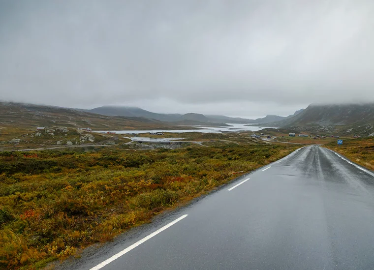
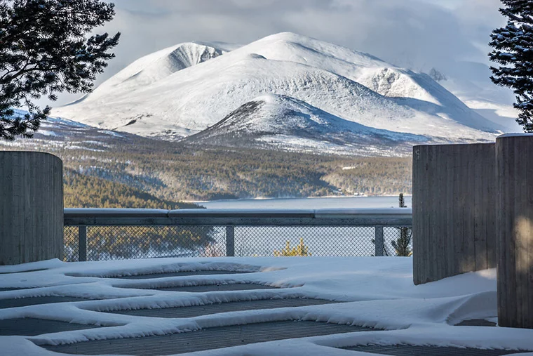
To truly appreciate the landscape, however, it is worth detouring east onto Route 27, one of Norway’s designated National Scenic Routes.
This 64-kilometre road skirts the eastern edge of the park, running between Ringebu and Folldal. Significant investment has transformed it into one of Norway’s most enjoyable scenic drives, complete with architect-designed rest stops, viewpoints, and picnic areas that encourage you to slow down.
Sollia Church
A short detour from Route 27 along Route 219 leads to Sollia Church, a small timber church built in 1738.
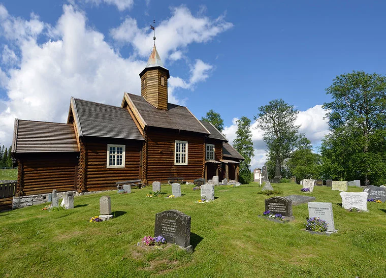
Constructed entirely by local residents who were weary of travelling long distances to Ringebu for services, the church stands as a quiet testament to rural perseverance in an isolated mountain valley.
Built as a simple log church, Sollia reflects the practical traditions of inland Norway rather than the grandeur of stave churches found elsewhere. Its painted interior, altar furnishings, and intimate scale create a strong sense of continuity with the farming community it has served for nearly three centuries.
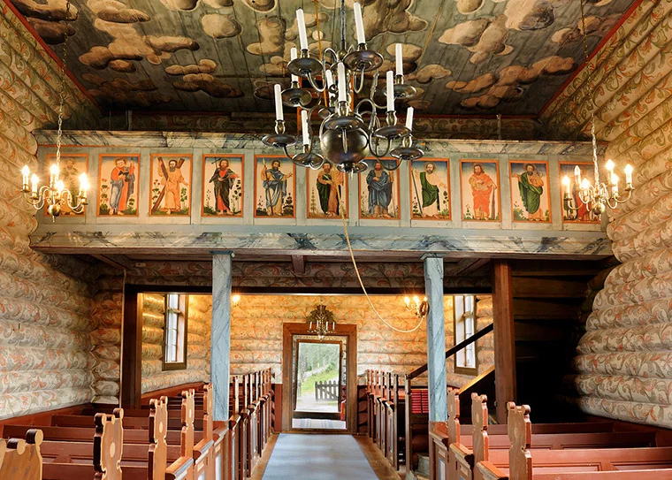
The church is normally only open for services, but visitors can arrange access in advance, and it is often open for limited hours during the summer season.
Atnabrufossen and Sohlbergplassen
Continuing north, the surroundings become increasingly tranquil. Near Atnabrufossen, a former sawmill and hydropower station now serves as a small museum. While exhibitions are occasional, the riverside setting makes this a pleasant place to pause, picnic, or simply listen to the water.
A short distance further on lies Sohlbergplassen, one of the most celebrated viewpoints on the Norwegian Scenic Routes network. Built to curve gently around existing pine trees, the platform frames a view across Lake Atnsjøen towards the Rondane peaks.
This exact perspective inspired Sohlberg’s 1914 painting Winter Night in the Mountains, a work that has become central to Norway’s national romantic imagination.
Strømbu and Folldal Mines
At Strømbu rest stop, the road meets one of the main gateways into the park’s interior. The modern restroom building includes a roof terrace overlooking the river, although facilities close from late October until Easter.
Further north, the industrial heritage site of the Folldal Mines offers a striking contrast to the surrounding wilderness. Operating from 1748 to 1993, the well-preserved complex of more than 70 buildings tells the story of mining life in an otherwise remote mountain region.
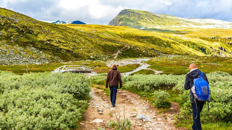
Hiking and Outdoor Life in Rondane
Hiking in Rondane is about immersion rather than conquest. Trails are well marked but rarely crowded, and the terrain encourages steady, thoughtful walking rather than dramatic ascents. The park suits both experienced hikers and those seeking longer but less technical routes.
The heart of the park lies around Rondvatnet lake, where Norwegian Trekking Association operates the popular Rondvassbu. Open during Easter and from late June through September, the lodge offers 128 beds and serves as a base for numerous day hikes and longer routes.
The walk to Rondvassbu from the Spranget car park is straightforward but lengthy, taking around 1.5 hours. In winter, marked cross-country ski trails replace footpaths, transforming the area into a quiet ski touring destination.
Seasonal closures are an important part of life in Rondane. Many trails and facilities close from May to early June to protect reindeer during the calving season. This restriction is essential to the park’s conservation role and is one of the reasons Rondane remains such an important wildlife refuge.
From Rondvassbu, hikers can reach several peaks, including Storronden, with a challenging but rewarding round trip of around five hours. Boat services operate on Rondvatnet during July and August, offering a scenic alternative to walking the full length of the lake.
Further east, trails from Strømbu lead through birch forest and open terrain to Bjørnhollia, another DNT lodge that provides access to quieter valleys such as Skjerdalen.
Cycling is also popular, particularly on Venabygdsfjellet and through the long Atndalen valley, where gradients are gentle and traffic is usually light.
When to Visit Rondane
Rondane is not a park of dramatic seasonal contrasts. Instead, it shifts quietly through the year, and understanding those shifts makes a huge difference to how much you enjoy a visit.
High summer, from late June through August, is when Rondane is at its most accessible. Trails are open, mountain lodges are staffed, and the long daylight hours encourage unhurried days outdoors. This is also when boat services run on Rondvatnet, making it easier to combine walking with time on the water.
Even in peak summer, however, Rondane rarely feels busy in the way more famous parks do. Its scale absorbs visitors, and the absence of headline attractions keeps crowds dispersed.
Early summer tells a different story. From May into early June, much of the park closes to protect wild reindeer during the calving season. Hiking routes may be restricted, mountain lodges shut, and access points limited.
While this can be frustrating for visitors unaware of the closures, it is also a defining feature of Rondane. The park prioritises wildlife over convenience, and this period highlights its role as a protected landscape rather than a recreational playground.
For those content to stay on the edges, early summer can still offer quiet walks, lingering snow patches, and a strong sense of seasonal transition.
Autumn is when many Norwegians consider Rondane at its best. From late August into September, the birch forests turn gold, the air sharpens, and visitor numbers drop noticeably.
Days are shorter, but often clearer, and the subdued colours of the landscape suit Rondane’s restrained character. Facilities begin to close as autumn progresses, so timing matters, but for hikers who value solitude and atmosphere, this is a particularly rewarding season.
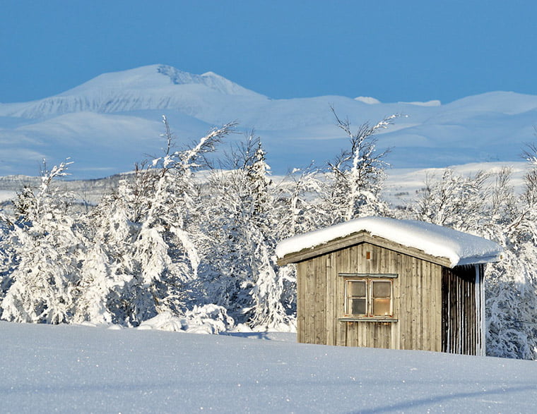
Winter transforms Rondane into something else entirely. Snow covers the plateaus, trails disappear, and silence dominates. Cross-country ski routes replace footpaths, and distances feel longer and more committing. Facilities are limited, weather conditions can change quickly, and experience matters.
This is not winter tourism in the Alpine sense, but a quieter, more self-reliant form of mountain travel that appeals to seasoned skiers rather than casual visitors.
Practical Information and Visitor Centres
Because Rondane is shaped so strongly by season and conservation needs, checking up-to-date information before you arrive is essential.
For maps, trail conditions, seasonal closures, and accommodation advice, the unstaffed Dombås National Park Centre provides detailed information not only on Rondane, but also on neighbouring protected areas. It’s a useful orientation stop, particularly if you’re combining several mountain regions in one trip.
Despite its remote feel, Rondane is one of Norway’s more accessible national parks without a car.
Otta sits on the Dovre railway line between Oslo and Trondheim and serves as the main public transport hub for the area. During July and August, seasonal bus services connect Otta with the Spranget trailhead, allowing hikers to reach Rondvassbu and the park interior using public transport alone.
Outside the high summer season, access without a car becomes more limited, and careful planning is required.
Why Rondane Stays With You
Rondane is not a place of instant gratification. Its appeal lies in repetition, familiarity, and the way the landscape slowly reveals itself.
For many Norwegians, it represents an idealised version of the mountains: open, quiet, and governed by respect for nature rather than spectacle.
Those who take the time to walk its valleys, drive its scenic roads, or simply sit and watch the light change across the peaks often find themselves wanting to return. That, more than any headline attraction, is what makes Rondane special.