Far from the Norwegian mainland, tucked between Greenland and Svalbard in the chilly waters of the North Atlantic, lies a volcanic island few people have heard of, let alone visited.
Jan Mayen is often grouped together with Svalbard in official statistics and Arctic policy, but in reality, the two places are surprising different.
While Svalbard has a small civilian population, a university, and a growing tourism industry, Jan Mayen is a closed military and meteorological outpost, with no permanent residents and almost no visitors.
It’s a place of extremes: howling winds, a glacier-capped volcano, and a harsh environment that only a handful of people experience each year.
But for those curious about the outer edges of Norway’s territory, Jan Mayen offers a fascinating glimpse into one of the most remote inhabited places on Earth, at least temporarily.
Jan Mayen: At a Glance
- Norwegian island in the North Atlantic, 1,000 km from the mainland
- Land area: 375 km²; surrounded by a 4,315 km² marine zone
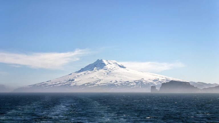
- Home to Beerenberg (2,277 m), Norway’s only active volcano
- World’s northernmost active volcano above sea level
- Volcanic landscape formed after the last Ice Age
- Proposed as a UNESCO World Heritage Site in 2007 (Mid-Atlantic Ridge)
Where is Jan Mayen?
Jan Mayen sits alone in the North Atlantic Ocean, roughly midway between mainland Norway and Greenland. It lies about 950 kilometres north of Iceland, 1,000 kilometres west of mainland Norway, and 600 kilometres south of Svalbard.
With no nearby islands, towns, or transport links, it’s one of the most remote parts of the Kingdom of Norway.
The island is narrow and crescent-shaped, stretching around 55 kilometres in length and just a few kilometres wide at most points. It covers a total area of 377 square kilometres (roughly the same size as Malta) but with a dramatically different landscape and climate.
Despite its Arctic location, Jan Mayen isn’t part of the polar ice cap. The surrounding ocean keeps temperatures surprisingly mild, although the weather is often cold, windy, and foggy.
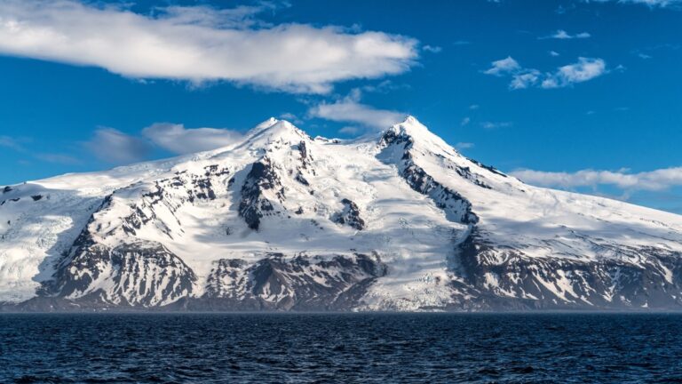
The island’s dramatic topography is dominated by Beerenberg, a 2,277-metre glacier-covered volcano that rises straight out of the ocean, making it the northernmost active volcano in the world.
Unlike Svalbard, there are no towns or settlements here. There’s just a single, heavily restricted station staffed by military personnel and weather researchers. There is no harbour, no airport for civilian use, and no infrastructure for visitors.
A Land of Fire and Ice
Jan Mayen’s landscape is shaped by fire, ice, and isolation. The island’s defining feature is Beerenberg, a snow-covered stratovolcano that looms over the northeastern part of the island.
At 2,277 metres tall, it’s the world’s northernmost active volcano and one of the few volcanoes on Earth to be permanently topped with glaciers.
Beerenberg last erupted in 1985, and previous eruptions have been recorded in the 18th and 20th centuries. Despite its remoteness, it’s still monitored closely by Norwegian authorities due to its potential impact on weather patterns and aviation.
The volcano’s glacial slopes feed into the island’s rugged terrain, which includes lava fields, steep cliffs, black sand beaches, and icy plateaus.
The rest of the island is relatively low-lying and barren, shaped by volcanic activity and battered by constant wind and waves. Much of the coast is inaccessible, with no safe harbours or landing spots except at a few carefully chosen locations.
The island is home to limited plant life and a few species of nesting seabirds. Arctic foxes were introduced during the trapping era, but no land mammals are native.
Despite the harsh conditions, Jan Mayen supports critical research into Arctic meteorology and geology—and remains one of the most geologically dramatic places under Norwegian control.
A Brief History of Jan Mayen
Although Jan Mayen is uninhabited today, its history stretches back more than four centuries, shaped by exploration, exploitation, and strategic use.
The island is named after Jan Jacobszoon May van Schellinkhout, a Dutch seafarer who charted part of the coastline in 1614. However, earlier sightings may have occurred, and some believe Irish monks or Norse seafarers knew of the island even earlier, although no evidence supports permanent settlement.
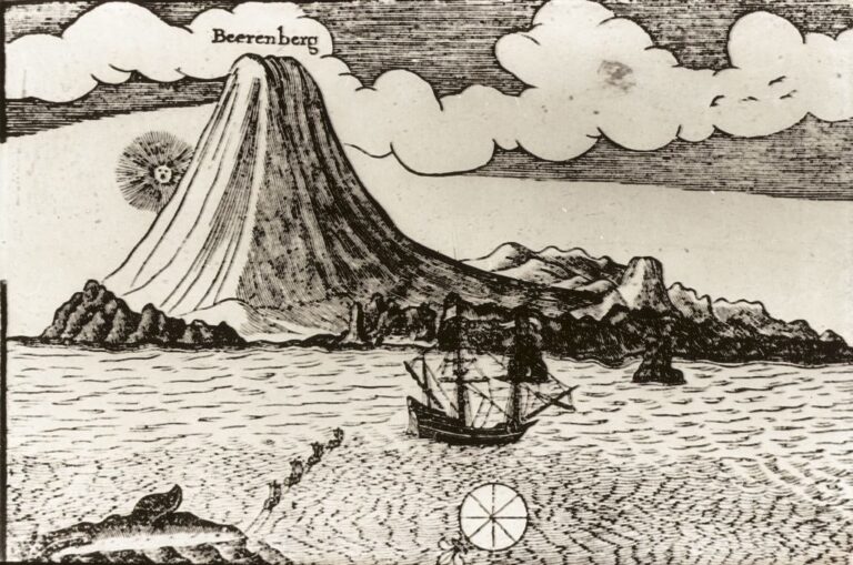
By the early 1600s, Dutch whalers began using Jan Mayen as a base during the summer hunting season. At one point, several hundred men worked here, boiling whale blubber into oil onshore.
These early whaling stations, now long gone, left behind only remnants of ovens and tools buried beneath volcanic ash and tundra. The island was abandoned for whaling within decades once local stocks were depleted.
In the centuries that followed, Jan Mayen was visited occasionally by trappers, scientists, and military vessels, but it was never permanently settled. Norway formally annexed the island in 1929, bringing it under national sovereignty.
During the Second World War, the island played a small but significant role. The Norwegian meteorological station continued to operate under Allied control after the Nazi occupation of mainland Norway.
Weather reports from Jan Mayen were vital to Allied convoys crossing the North Atlantic, and the station was occasionally threatened by German aircraft.
Since then, Jan Mayen has remained under Norwegian control, primarily used for meteorological and military purposes, with a small rotating crew maintaining operations year-round.
Life on Jan Mayen Today
No one lives on Jan Mayen permanently, but the island is staffed year-round by a small rotating crew.
Typically, around 15 to 18 people are stationed here at any given time, split between personnel from the Norwegian Armed Forces and the Norwegian Meteorological Institute.
Their job? To operate the island’s weather station, maintain the military infrastructure, and ensure Norway maintains its strategic presence on this remote outpost.
Daily life on Jan Mayen is defined by isolation. Supplies arrive by ship just a few times per year, usually from mainland Norway or Iceland. A gravel airstrip is usually used only for military and emergency flights but does allow for occasional personnel changes when weather permits.
There are no shops, no roads to speak of, and no internet beyond what’s necessary for communication and research. Yet those stationed on the island live in relative comfort, with access to hot meals, shared living quarters, a small gym, and a satellite TV connection.
The sense of community is strong, built out of necessity. Meals are eaten together, routines are shared, and recreation comes from simple pleasures such as board games, books, or walks across the stark volcanic landscape. Weather permitting, of course. Many describe the experience as both challenging and unforgettable.
Despite its remoteness, Jan Mayen plays an important role in global weather forecasting. Data collected here helps improve models for the North Atlantic and Arctic regions, particularly for storm tracking and aviation.
For those stationed on Jan Mayen, life moves at a slower, wind-blown pace. There are few distractions. Just work, weather, and the wild northern silence.
Can You Visit Jan Mayen?
In short: yes, but for most people, not really.
Jan Mayen is one of the most inaccessible places in the world. There are no regular transport links, and all visits require special permission from the Norwegian Armed Forces, which controls access to the island.
As mentioned there is just a small military airstrip used for supply and personnel flights when weather allows. The island has no harbour, so landings by sea are only possible in calm conditions, typically using small boats launched from an anchored ship offshore.
That means it’s not a cruise destination either, at least, not for mainstream cruise lines.
A small number of expedition cruises do include Jan Mayen on their itineraries, particularly those heading between Iceland and Svalbard. But even then, landings are never guaranteed. Rough seas, fog, or high winds often prevent passengers from going ashore.
If you're lucky enough to set foot on Jan Mayen, expect a guided walk from the landing site to the military base and perhaps a chance to view Beerenberg, weather and security permitting. Independent travel is not possible, and camping or overnight stays are not allowed without pre-authorised arrangements.
For most, Jan Mayen remains at best an intriguing “seen from the ship” destination, an almost mythical place at the edge of Europe, reserved for the most determined Arctic travellers.
Why Jan Mayen Matters
Jan Mayen may be remote and rarely visited, but it still plays an important role for Norway. Its location extends Norwegian presence far into the North Atlantic, supporting Arctic weather forecasting, scientific research, and national sovereignty.
The island also captures the imagination. With its stark volcanic landscape, extreme isolation, and limited human presence, Jan Mayen stands as one of the few places on Earth that remains largely untouched.
For many, it represents the very edge of civilisation and a reminder of Norway’s far-reaching geography.