Norway is home to some of Europe’s most dramatic glaciers, where ancient ice meets rugged mountain landscapes. Best of all, several of these natural wonders are surprisingly easy to visit, whether you're looking for a guided ice hike or simply a chance to take in the view.
Sometimes, nature reminds you who's in charge. Rarely can this be seen more than when faced with the raw untameable power of a glacier.
Whether you're planning a trip or just curious about how these remarkable features formed, here's everything you need to know about Norway’s glaciers: how they began, where to see them, and why now is the time to go.
Table of Contents
How Are Norway's Glaciers Formed?
Glaciers begin with snowfall. In areas where more snow falls in winter than melts in summer, layers build up over time. As the weight increases, the lower layers compress into dense ice.
Eventually, the pressure becomes so great that the ice starts to move, slowly, but with immense force, flowing down valleys or spreading out across the landscape.
This gradual movement is more powerful than it might seem. Over centuries, glaciers carve out deep valleys and dramatic fjords, leaving behind the rugged scenery that defines much of western Norway today.
The last ice age played a major role in shaping Norway’s terrain, but glacier activity didn’t stop when the ice age ended. During the so-called Little Ice Age (roughly 1650 to 1750), Norway’s glaciers advanced significantly, and some reached their maximum size in recorded history.
Today, these icy landscapes are retreating as global temperatures rise. But they remain an incredible window into the past, and one of the most humbling sights you can see in Norway’s great outdoors.
Where are Norway's Glaciers?
You might expect to find most of Norway’s glaciers in the far north, but the largest and most accessible ones are actually located much further south thanks to the high elevation of Norway’s mountain plateaus and heavy snowfall in these regions.
From the vast ice cap of Jostedalsbreen in Vestland to the sparkling arms of Folgefonna in Hardanger and the dramatic slopes of Svartisen in Nordland, these icy giants are scattered throughout the country’s mountainous interior. Some can be seen from the roadside, while others require a bit of hiking to reach.
Staying Safe on the Norwegian Glaciers
Planning a hiking trip in Norway needs careful attention at the best of times, but never more so than around glaciers.
Even when it looks impossible, ice is always moving. The movement of these giant blocks is strong enough to carve up the earth. In fact, that's exactly how Norway's famous fjords were created in the first place.
Because of deep crevasses, the constant and unpredictable movement of the ice, and the risk of avalanches, extra care must be taken.
First and foremost, you should never attempt to hike a glacier on your own, no matter how experienced a hiker you are. Local guides are highly trained in leading groups on glaciers, have full rescue equipment, and know the location inside out.
In some places a hike brings you to within view of one the glacier arms and that stretch is of course fine to hike without a guide, but never set foot on a glacier without professional supervision.
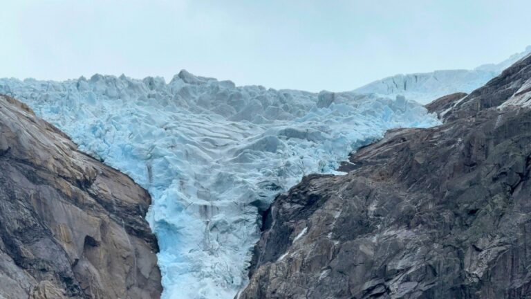
Jostedalsbreen
At approximately 474 square kilometres, Jostedalsbreen in Sogn og Fjordane county is the largest glacier on mainland Europe. I say approximately, because the rate of shrinking of this glacier in recent years has been quite alarming.
Because of the sheer size of Jostedalsbreen, it's actually better known as a tourist destination at its two most prominent and accessible arms: Nigardsbreen and Briksdalsbreen, so let's start there!
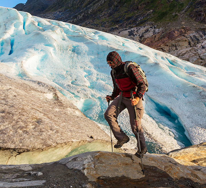
Nigardsbreen
We shall start our tour by taking a look at the most easily accessible of all Norway's glaciers. It's also one of the most famous thanks to Norwegian landscape artist Johan Christian Dahl.
Because of its fame and accessibility, Nigardsbreen is one of the best places to take an ice hike. Several local companies run tours, some even aimed at families with children as young as eight-years-old permitted to take part.
The Nigard Glacier (as it's often referred to in English) is located west of the Jostedøla river around 30km north of Gaupne in.
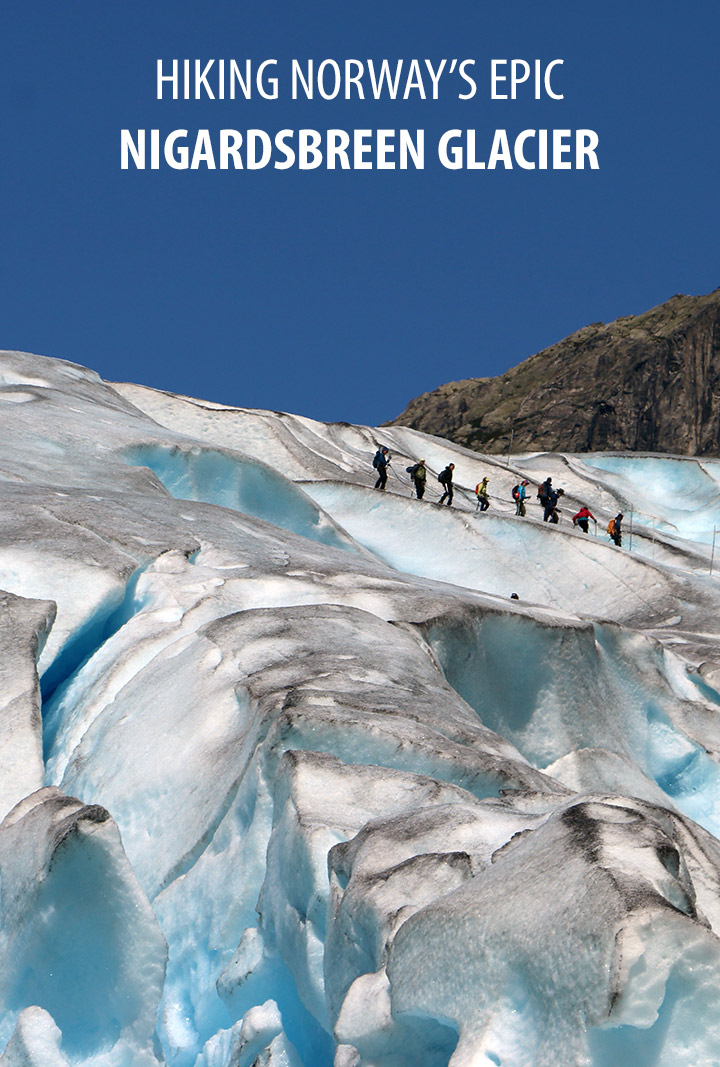
Around 10km south you'll find Breheimsenteret in the village of Jostedal, which acts as the visitor centre for the glacier and national park. It's from here most of the tours leave from.
To reach the glacier, take the 3km toll road by bus or in your own car from Breheimsenteret to the parking spot. From there you can either walk around the lake or take the boat (summer only) right across it.
Briksdalsbreen
Briksdalsbreen is one of the most popular and picturesque arms of the vast Jostedalsbreen glacier.
Located near Olden on the Nordfjord, the glacier plunges from high on the mountain plateau down towards a glacial lake surrounded by steep cliffs and waterfalls. The scenery is striking, with snow-capped peaks, cascading water, and the distinct blue ice of the glacier itself.
Most visitors take the 2.5 to 3 kilometre walking trail from the mountain lodge up to the viewpoint near the glacier front. The path is well maintained and gently uphill, making it suitable for most people with a basic level of fitness.
For those who prefer not to walk, small open-air vehicles known as ‘troll cars’ operate during the main season from spring to autumn, offering a scenic ride through the valley.
In recent decades, Briksdalsbreen has retreated dramatically. At its peak in the 1990s, the glacier reached right down to the lake. Today, it sits well back from the shoreline, high on the valley wall.
The pace of retreat has been so rapid that it is no longer possible to walk on the glacier safely, and all guided hikes have been moved to other glacier arms in the region.
Folgefonna
Three glacial plateaus in the Hardanger region of south-west Norway are collectively known as Folgefonna. The total area of Nordre Folgefonna (26km²), Midtre Folgefonna (11km²) and Søndre Folgefonna (167m²) is vast, stretching over the municipalities of Odda, Jondal, Kvinnherad, and Etne.
Since 2005, the complete Folgefonna area has been protected with National Park status. One of the most accessible parts of the glacier is the hike from Odda on the southern end of the Sørfjord to the Buerbreen arm.
Since 2017, Rosendal has been home to the new Folgefonn Centre, a visitor centre covering the Folgefonna National Park but also diving deep into topics including the climate, life in the ocean and the fjords, and the biological diversity of the area.
From mid-June to mid-August, guided six-hour blue ice hikes are held that, depending on conditions, allow access to some of the spectacular crevasses that slice through the ice.
The nearby FONNA Ski Resort offers the rare opportunity for summer skiing in Norway. Alpine skiing, freestyle skiing, a snowboarding park, cross-country trails and guided snowshoe hikes are all available.
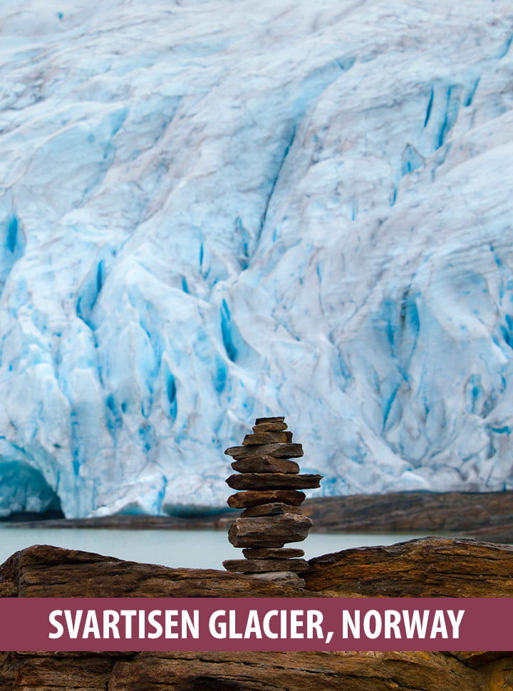
Svartisen
In the heart of Nordland, Svartisen is the name given to two glaciers—Vestre Svartisen and Østre Svartisen—that were once part of a single vast ice cap just a few centuries ago.
Vestre Svartisen is the larger of the two, covering approximately 221 square kilometres. That makes it the second largest glacier on the Norwegian mainland, after Jostedalsbreen.
One of its most remarkable arms is Engabreen, which flows down to just 20 metres above sea level. This makes it the lowest-lying glacier terminus in mainland Europe, and one of the easiest places to see glacier ice up close, despite its remote location.
Svartisen receives far fewer visitors than the better-known glaciers of southern Norway, giving it a quieter, more off-the-beaten-path appeal.
From the small town of Holandsvika, visitors can cross the Holandsfjorden by boat and hike or cycle to the glacier front. In summer, kayak rentals and boat trips offer alternative ways to experience the dramatic scenery.
The glacier also plays an important role in hydropower production, with water from the ice melt collected and used in nearby power stations.
The Glaciers of Svalbard
While the mainland gets most of the attention, the majority of Norway’s glaciers are actually found much further north in the Svalbard archipelago, deep in the Arctic.
Around 60 percent of Svalbard’s landmass is covered by permanent ice. Many of these glaciers are between 3,000 and 4,000 years old, and they continue to shape the rugged, isolated terrain of these high-latitude islands.
The largest ice caps are found on the eastern islands, with Austfonna on Nordaustlandet being the biggest by far. Covering over 8,000 square kilometres, it ranks among the largest ice caps in Europe.
On Spitsbergen, the largest of the Svalbard islands, the dominant glacier form is the so-called “Spitsbergen-type” glacier.
These are complex systems made up of large interconnected ice fields, separated by mountain ridges into smaller ice streams and individual glacier fronts. This patchwork of ice and rock creates a dramatic and constantly shifting Arctic landscape.
A Glacier Dictionary
If you’re planning to visit one of Norway’s glaciers—or simply want to understand what your guide is talking about—here’s a helpful glossary of some of the most common glacier-related terms you might come across:
Arm / Outlet Glacier: A smaller offshoot of a larger ice cap or main glacier. These are often the most accessible parts for visitors. Nigardsbreen and Briksdalsbreen are both arms of the vast Jostedalsbreen.
Calving: The process where chunks of ice break away from the front of a glacier, sometimes falling into a lake or fjord to form icebergs. This is especially common in glaciers that end at the water, such as those in Svalbard.
Crevasse: A deep, open crack in the glacier’s surface, formed as the ice moves and stretches. Some crevasses are visible, while others may be hidden under a thin layer of snow, making them especially dangerous.
Firn: A stage between snow and glacial ice. Firn is older, compacted snow that has survived a full year of seasonal melting and refreezing, gradually transforming into dense ice.
Front / Terminus: The lowest end of a glacier, often referred to as the glacier’s snout. When a glacier retreats, this point moves higher up the valley.
Glacial Lake: A body of water formed by the melting of a glacier. These lakes may form in depressions carved out by glacial movement or behind natural dams created by moraines.
Glacier Lake Outburst Flood (GLOF): A sudden and often violent release of water from a glacial lake. GLOFs can cause serious flooding downstream and are closely monitored in vulnerable areas.
Ice Cap: A large mass of glacial ice that spreads out from a central point, typically covering less than 50,000 square kilometres. Norway has several ice caps, including Folgefonna and Svartisen.
Icefall: A steep section of a glacier where the ice flows rapidly and becomes heavily crevassed. Icefalls resemble frozen waterfalls and are among the most dangerous areas on a glacier.
Jøkul: An old Norwegian word for glacier. While no longer common in everyday language, it appears in place names and older literature.
Moraine: A collection of rocks and sediment left behind by a moving glacier. Moraines often mark the edges or former extent of a glacier and are common features in glaciated valleys.
Perennial Snowfield: A patch of snow that remains year-round but lacks the mass or movement of a true glacier. These snowfields are often found at higher elevations.
Retreat: The process of a glacier shrinking as more ice melts than accumulates. Most glaciers in Norway are currently in retreat due to rising temperatures.
Serac: A large, often unstable block or tower of glacial ice, commonly found in icefalls. Seracs can collapse without warning and are extremely hazardous.
Snowline: The lowest elevation where snow remains all year. The position of the snowline plays a major role in glacier health and varies with climate and geography.
Tidewater Glacier: A glacier that ends directly in the sea. These are mostly found in Svalbard today, but they once occurred more widely along the Norwegian mainland coast.
Understanding this vocabulary helps make sense of what you see on a glacier tour and gives you deeper insight into the natural processes that have shaped Norway’s iconic landscape.

Hi David, thanks, this was a great list. We are heading to Norway in June and I am struggling to work out which glacier we should be visiting (with kids, so that makes it harder to pick a suitable glacier), Many thanks, Amber