
Are you planning a trip to Norway’s oil capital to hike the famous Pulpit Rock? Find out what other hiking trails the Stavanger region has to offer. Whether you're renting a car or using public transport, there's options here for you!
Stavanger is a hotspot for anyone who wants to combine exploring a charming Norwegian city with discovering what the great outdoors has to offer.
After all, the city is situated a quick 30-minute drive through the newly-built Ryfast Tunnel from the gorgeous Lysefjord, one of the most beautiful fjords in Norway.
Here you'll find an abundance of spectacular viewpoints and hiking trails. Plus, it's just an hour’s drive from Magma Geopark, a UNESCO park landscape formed 1,500 million years ago.
In other words, Stavanger makes for the perfect Norwegian city to visit if you’d like to spend some time hiking while still discovering the local culture and cuisine. These are some of the best trails in and around Stavanger:
Table of Contents
Pulpit Rock (Preikestolen)
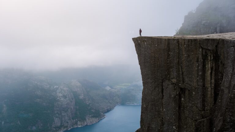
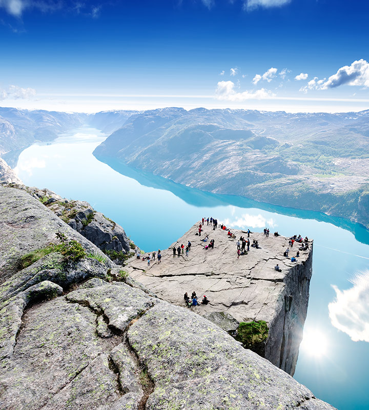
No list of Stavanger hikes would be complete without Norway’s most famous trail. Pulpit Rock, or Preikestolen, is a vast mountain plateau that juts 604 metres above the Lysefjord.
The hike is one of the most popular in the country, attracting more than 300,000 visitors every year.
The 8-kilometre round trip begins at Preikestolen Mountain Lodge, about 40 minutes’ drive from Stavanger or accessible by direct bus in summer. The path has been improved in recent years by Nepalese Sherpas, who built stone stairways across the steepest and muddiest parts, making it safer and more sustainable.
Most people take two to three hours each way, but it depends on fitness level and how crowded the trail is. Along the route you’ll pass small lakes, forested stretches, and dramatic viewpoints that hint at the final reward.
The last section runs across a narrow path with sheer drops to one side, a reminder to tread carefully.
At the top, the 25 by 25 metre clifftop seems to hang in midair above Lysefjord. Many visitors inch their way to the edge for photos, while others sit back to soak up the atmosphere.
If you go early in the morning or late in the evening, you’ll avoid the worst of the crowds and may even catch a spectacular sunrise or sunset over the fjord.
Safety is worth emphasising: there are no railings at the top, and every year rescue teams are called out for unprepared hikers. Sturdy boots, layered clothing, and water are essential, and you should allow a full day to do the trip without rushing.
Kjerag
If Pulpit Rock is Norway’s most famous viewpoint, Kjerag is its daredevil cousin. Towering 1,084 metres above the Lysefjord, this mountain is home to the legendary Kjeragbolten — a giant boulder wedged between two cliffs. Brave hikers step onto it for one of the country’s most iconic photos, balancing above a kilometre of empty air.
The 10-kilometre round trip to Kjerag is far more demanding than Preikestolen. Starting from the car park and café at Øygardstøl (known as the Eagle’s Nest), the trail climbs steeply three separate times across bare granite slabs.
Chains are bolted into the rock for support, and in wet weather the stone can be slippery, so good boots and caution are essential. Expect the hike to take 6–10 hours depending on fitness and conditions.

Despite the challenge, Kjerag is hugely rewarding. The plateau offers sweeping views over the length of the Lysefjord, often with base jumpers leaping from the cliffs in summer. The sheer vertical walls drop dramatically to the fjord, creating one of Norway’s most dramatic landscapes.
Getting to the trailhead requires more planning than Pulpit Rock. Øygardstøl is about 2.5 hours from Stavanger by car, via the Lysebotn Road with its famous 27 hairpin bends. Public transport options are limited and seasonal, so most visitors drive.
The hike is only accessible from late May to September, as snow lingers on the plateau well into spring.
Because of its difficulty, Kjerag sees fewer crowds than Preikestolen, making it ideal for hikers who want something wilder and more remote. Standing on Kjeragbolten is not compulsory—many people are happy just to admire it—but for those with steady nerves, the thrill is unforgettable.
Flørli 4444
Before we leave the Lysefjord, we can't miss out this rather unusual option for fitness fanatics!
Deep inside Lysefjord lies the small village of Flørli, accessible only by boat. Once home to a hydropower station, the village is now a quirky visitor stop with cabins, a café, and the world’s longest wooden staircase.
Climbing the 4,444 steps is an adventure in itself, rising 740 metres from the fjord to the mountain plateau above. The effort is rewarded with spectacular views, but it is physically tough, especially on hot days.
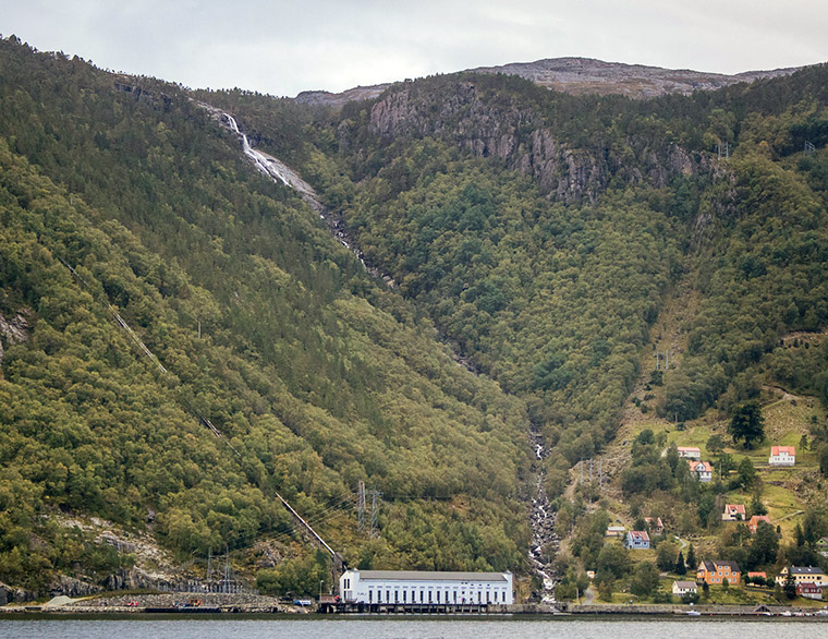
Bring plenty of water and take your time. Ferries from Stavanger and Forsand connect to Flørli, making it possible to hike up and take an alternative trail back down for variety.
Dalsnuten
For a shorter outing close to the city, Dalsnuten is the locals’ favourite. Standing at 323 metres, it’s more hill than mountain, but the views over Stavanger, Sandnes, and the North Sea beyond are well worth the climb.
Two main paths lead to the top from the car park at Gramstad, one rocky and direct, the other gentler but slightly longer. The round trip takes about two to three hours, making it an ideal half-day hike.
The trailhead is served by bus, so you don’t need a car. Pack a picnic and enjoy the panorama from the grassy summit.
Store Stokkavannet
Not every hike near Stavanger involves dramatic fjords and sheer cliffs. Just a couple of kilometres west of the city centre lies Store Stokkavannet, a freshwater lake surrounded by woods and meadows.
The flat 8-kilometre path around the lake is perfect for families, runners, and cyclists.
On sunny summer days, locals flock here for swimming and picnics, but it’s equally enjoyable for a peaceful walk at any time of year. The lake is easily reached by local bus, making it a convenient escape from the city bustle.
Trollpikken
Few natural landmarks in Norway have a story as curious as Trollpikken, literally “the troll’s ****.”
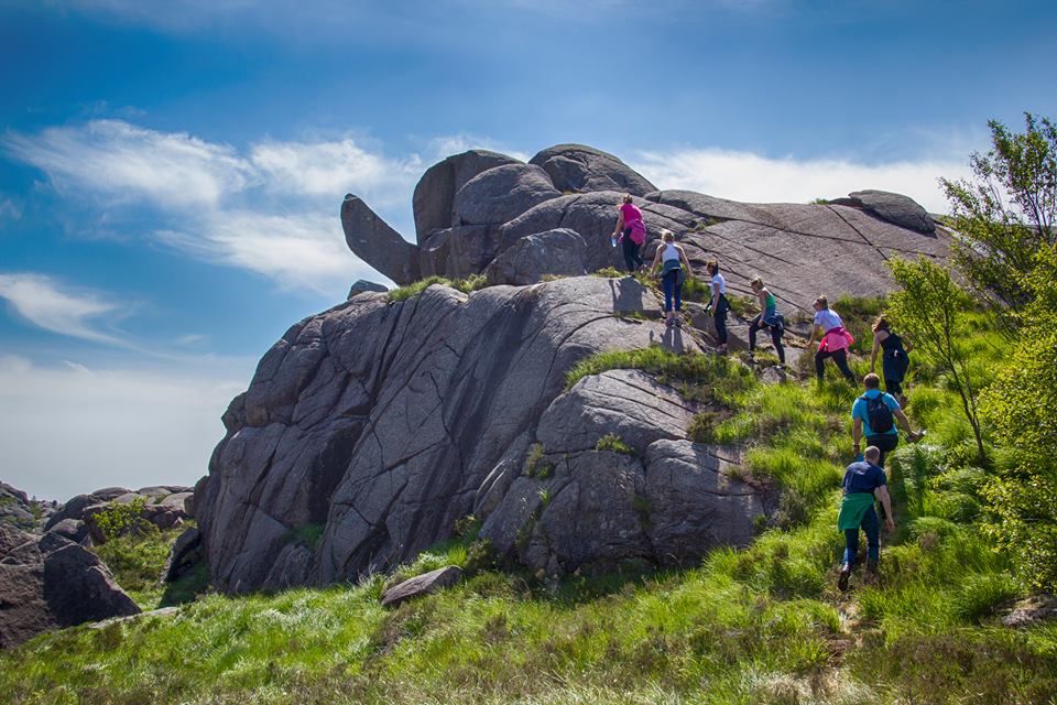
This phallic rock formation in Magma Geopark became world news in 2017 when vandals toppled it, only for locals to raise funds and restore it to its original position.
The 5-kilometre hike to Trollpikken begins near Egersund, about 75 minutes south of Stavanger. The path is fairly easy and suitable for most walkers, but sturdy shoes are recommended.
At the summit, the landscape of bare rock and glacial grooves stretches out like a moonscape, a reminder of the region’s ancient geology.
Månafossen
At 92 metres, Månafossen is the highest waterfall of Rogaland County. There are several different hiking trails to choose from, but the actual trail leading up to the first viewing plateau to see the waterfall is actually more of a climb – a 400m long one.
There are plenty of ropes for support, however, so that the trail is definitely suitable for anyone of average fitness and even families with children.
If that’s not enough of a challenge for you, you can easily continue the trail further to Friluftsgården Mån, an old farmhouse abandoned back in 1915 that is now used as a cabin and local history museum.
The Beaches of Jæren
To the south of Stavanger stretches Jæren, a coastline famous for its endless sandy beaches, a rarity in fjord-filled Norway. Unlike the dramatic cliffs of Lysefjord, this is open landscape where sea and sky dominate, making it perfect for long, windswept walks.
Solastranden, just 15 minutes from the city and right next to the airport, is the most accessible. Its golden sands attract swimmers, kite-surfers, and families in summer, but it’s equally enjoyable for a bracing stroll on a windy day.
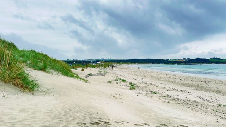
Further south, Borestranden and Orrestranden offer longer stretches of sand and a wilder feel, with rolling dunes and the crash of Atlantic waves.
Jæren is also a protected landscape area, home to migrating birds and fragile dune ecosystems.
If you’re visiting, stick to marked paths and respect local signs. The beaches of Jæren are easily reached by car or public transport from Stavanger, making them a refreshing contrast to mountain hikes and a reminder of Norway’s varied natural beauty.
Mosvatnet
If you only have an hour or two in Stavanger and don’t want to stray far from the centre, Mosvatnet is a great option. This freshwater lake lies just a short walk from the city centre and features a flat 3-kilometre path around its shoreline.
The circuit is popular with joggers, families, and dog walkers, making it a lively spot where you’ll feel part of everyday Stavanger life.
Along the way you’ll find benches, picnic areas, and even small art installations dotted around the lake. In spring and summer, birdlife is abundant, and in autumn the trees provide colourful reflections in the water.
Mosvatnet may not offer dramatic fjord views, but it’s the most accessible nature escape in the city, ideal for stretching your legs before or after exploring Stavanger’s harbour and museums.
Ullandhaug
For a short but rewarding climb, head to Ullandhaug, a 138-metre hill just east of the city centre near the University of Stavanger.
At the summit stands Ullandhaug Tower, a telecommunications structure with an observation deck that provides sweeping views over Stavanger, the Ryfylke islands, and out to the North Sea. On clear days, you can even spot the mountains rising behind Lysefjord.
The walk up is short and straightforward, taking 20–30 minutes from the nearest bus stop. Trails wind through woodland and open grassland, making it a pleasant urban hike.
The area is also of historical interest: Ullandhaug was once the site of an Iron Age farm, now reconstructed nearby as an open-air museum.
For visitors without a car, Ullandhaug is one of the easiest ways to enjoy a panoramic view of Stavanger and its surroundings.
Have you been hiking in the Stavanger region? If so, what's your favourite trail? Let us know in the comments, and please do share this post on Pinterest if you've been inspired. Just hit those social sharing buttons.

Thanks. I hiked Preikestolen when we lived in Stavanger. I miss this wonderful country and the people.
Wonderful, and makes me sad. I had a trip booked to be in Stavanger right now, and to visit Ogna, where one of my great grandfathers was born, and is buried in the local churchyard. I hope to be able to go next year.
I found your blog to be very interesting and informative. My husband and I are planning a trip to Norway this Summer, would really like to hike Kjeragbolten. I am 70 years old and my husband is 74. We are in fairly good shape, had tracked to the base camp of Mt Everest. Do you think Kjeragbolten will be too difficult for two elderly?