From an enormous, permanently frozen rock in the North to a sunbathers' paradise in the South, via countless cosy fishing villages along the way: this is our overview of Norway's most notable islands.
The country boasts one of the world's longest and most rugged coastlines, dotted with innumerable islands.
Some of them are accessible only by plane or supply ships, others have a regular ferry service and others still are linked to the mainland by bridges or tunnels.
Whether you're looking for total isolation, exoticism, adventure or history, we've got you covered with an island. Read on as we present you with our selection of the most notable Norwegian islands.
Svalbard
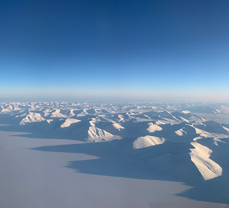
Reaching as far up North as 81° of latitude, Svalbard is probably the furthest North you can ever hope to go – unless you’re some kind of polar explorer.
Technically speaking, the name Svalbard doesn’t refer to an island but to the whole archipelago, composed of the islands of Spitsbergen, Nordaustlandet, Edgeøya and many other smaller ones.
The largest settlement, Longyearbyen, is easily accessible by plane from Oslo and Tromsø. It boasts a university, a few hotels and several tour operators offering once-in-a-lifetime experiences to eager tourists in want of northern lights, dog sled rides and polar bear safaris.
Longyearbyen is also famous for being the home of the Global Seed Vault, also known as the Doomsday Vault. The facility is intended as a fail-safe seed storage centre, built to stand the test of time and meet the challenge of natural or man-made disasters.
Speaking of natural disasters, Svalbard is particularly threatened by global warming. If the permafrost thaws, buildings could sink or collapse, and large landslides could occur.
The Svalbard treaty
The second largest settlement on Svalbard is Barentsburg, a Russian mining town. How can there be a Russian town in Norway you ask? Well that’s because of Svalbard’s unique status.
Read more: The Fascinating History of Svalbard
The archipelago was used as a base for whaling as early as the 17th century. Whaling activities diminished with time, and ceased completely in the 19th century.
But by the 20th century, the discovery of coal in the archipelago generated renewed interest in the area (both Longyearbyen and Barentsburg were founded as coal-mining towns).
Shortly after the First World War, the Svalbard Treaty granted full sovereignty over the archipelago to Norway, with the caveat that all of the treaty’s signatory countries would get non-discriminatory rights to fishing, hunting and mineral resources.
One consequence of that is that even though Svalbard is a part of Norway, it is not, like the rest of the country, part of the European Economic Area or the Schengen Agreement.
Jan Mayen
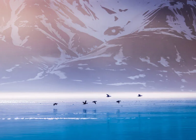
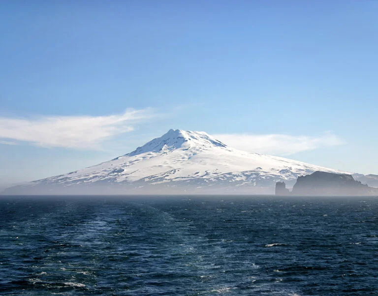
South-west of Svalbard, about two-thirds of the way to Iceland, lies the island of Jan Mayen.
This volcanic island has no permanent population, but around 20 people (a few more in the summer) are in service there at all times, either working for the Jan Mayen meteorological station, the Norwegian military or as support staff.
The island was identified as an “Important bird area” by the conservation group BirdLife International, because it is a breeding site for many species of seabirds. Tourism on Jan Mayen is mostly non-existent.
There are no regular flights, which means the island is only accessible by chartered planes. Permission to stay on the island has to be obtained in advance and strong conservation rules mean putting up a tent or a camp is prohibited.
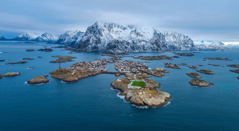
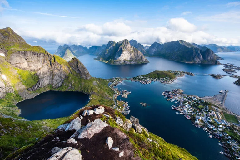
The Lofoten archipelago
One of the bright tourism stars of Norway, the Lofoten archipelago is certainly worth the detour. Even if you’ve never heard of it, you’re certain to have seen images of quaint fishing villages nestled under Tolkien-esque peaks emerging from the sea.
The main islands of the archipelago are Hinnøya, Austvågøy (though just portions of these two are considered as being part of Lofoten), Gimsøya, Vestvågøy, Flakstadøya and Moskenesøya.
Lofoten is easily accessible by ferry from Bodø. You can get to Bodø by plane or by train from Oslo. Flights by regional carrier Widerøe can also get you directly there, to Svolvær, Leknes and Røst. If ferries or planes aren’t your cup of tea, you can get there by road, via Narvik.
The Lofoten islands are an ideal destination for photography, sea fishing, whale watching and hiking. But the views are really the main attraction.
The rocky peaks emerging from the water, the brightly coloured fishing shacks, the wooden racks where cod is hung to dry, the surprisingly white and tropical-looking beaches; the archipelago has all it takes to send Instagram users into overdrive.
One notable fishing village is picture-perfect Reine, located on Moskenesøya. Reine is just a few kilometers from the Moskenes ferry terminal.
Skrova
Also well worth a detour is the tiny island community of Skrova, which boasts a vibrant art community despite having only some two hundred residents.
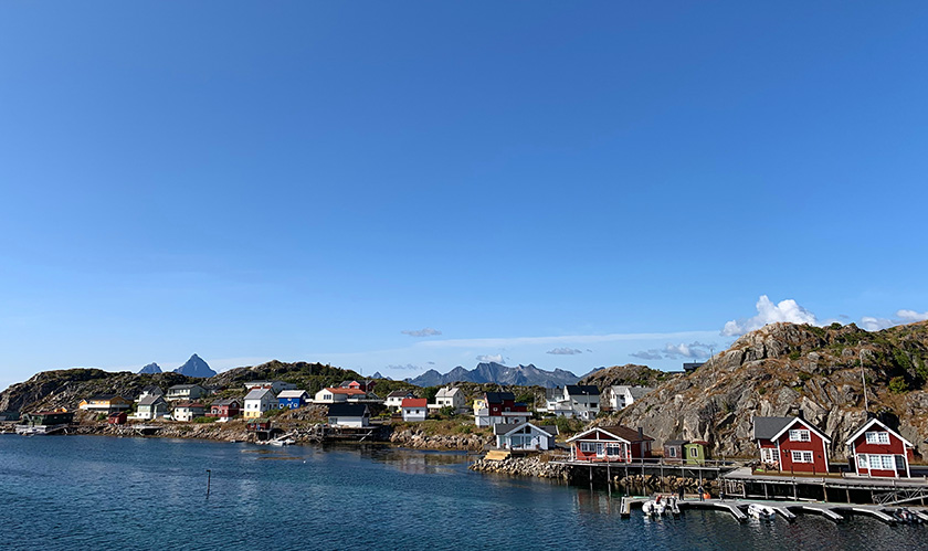
It is reached by the Svolvær to Skrova ferry link, which is largely ignored by most people travelling along the E10.
The fact that it’s such a hidden gem is a part of the island’s charm. There’s even a bicycle hire scheme that allows you to see all the sights in a short time.
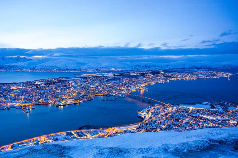
Tromsøya
A list of important Norwegian islands wouldn’t be complete without Tromsøya, the island on which Tromsø lies. The city is a sought-after destination for northern light hunters, and a popular stop for tourists on their way to the North Cape.
Top attractions are the Storsteinen mountain cable car, which offers an incredible view of the city, the famous Arctic Cathedral and the Northern Norway Art Museum. There are regular direct flights from Oslo.
Stord
Just south of Bergen, and accessible by a ferry via the E39 is the island of Stord. The ferry ride when coming from Bergen takes about 40 minutes. Even so, you would be forgiven for driving through it without ever realising you're on an island.
That's because at 241 km2 (about 93 square miles), the island is one of Norway’s largest. It’s dominated by the pyrite mountain Mehammarsåta, so much so that the island's only roads loop around the edge.
If visiting, steer away from the E39 and opt instead for the more rural roads that follow the island’s west coast. Those scenic roads are dotted with picturesque spots, with that area of Norway’s typical mix of coastline, visible bedrock and evergreen trees.
Hovedøya
If your trip to Norway includes a stop in Oslo – and let’s face it: it almost certainly does – the Oslo fjord has a number of interesting islands to visit.
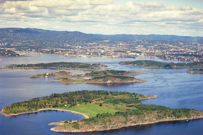
One of these, Hovedøya, is but a short passenger ferry ride from town. If you visit it on a warm summer day, its beaches will be packed with sunbathers.
One notable attraction is the ruins of Hovedøya Abbey, a 12th-Century Cistercian monastery built by English monks. In the summer, you can have a bite at a little café located close to the ruins.
The island also has old military installations: two cannon batteries and an arsenal for the nearby Akerhus fortress, storing such naughty things as gunpowder.
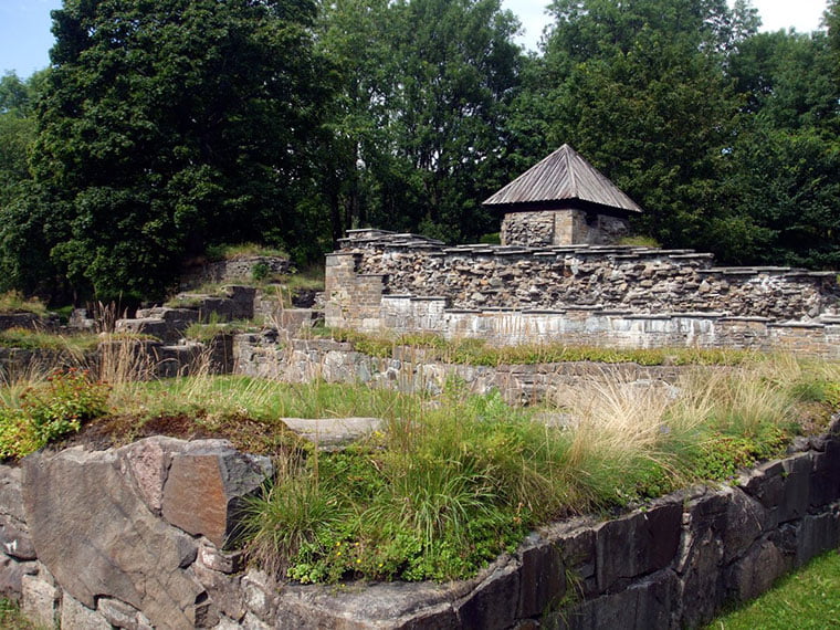
One of those buildings has been converted into an art gallery and is well worth a visit, both for the art and for the lovingly restored architecture.
Other notable Oslofjord islands are Gressholmen and Lindøya.
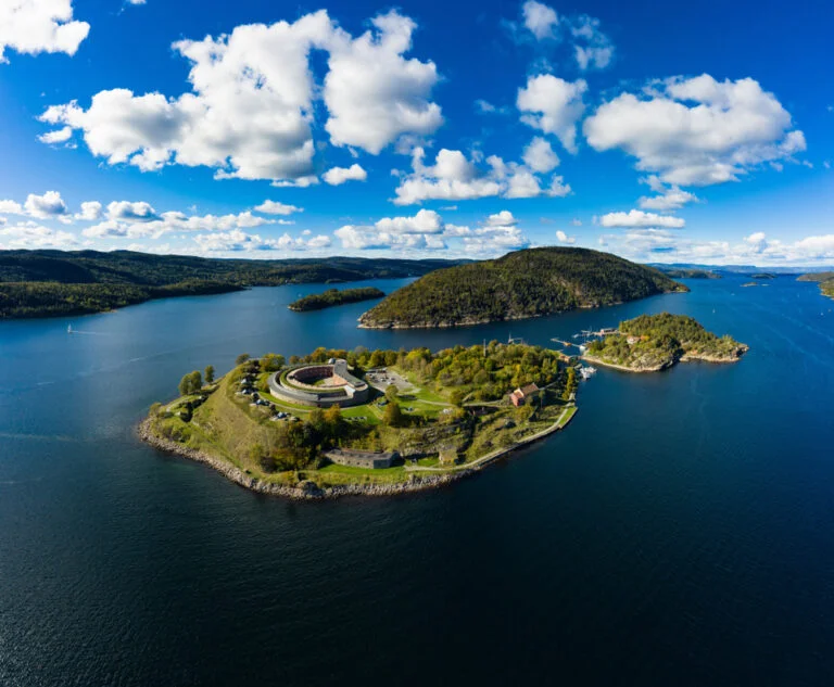
Oscarsborg
Further south on the Oslofjord lies Oscarsborg, an island that’s home to the fortress of the same name. If you travel to Oslo from Denmark or Germany by ferry, you will get a good view of the island and its fortifications.
Seeing it from that vantage point, it’s easy to understand why the island was chosen for such a purpose. The fjord narrows in that area, and the canons located on the island can easily bombard passing ships.
The first fortifications were built as early as 1644, by King Christian IV of Denmark and Norway. The current fort was built in the middle of the 19th century. The fortifications actually played a role in actual conflict, during the invasion of Norway by Germany in 1940.
At that time, the fortress’ armaments were already 40 years old, but the Germans were unaware of the underground torpedo facility the island housed.
This allowed the Norwegians to sink the heavy cruiser Blücher, which delayed the German advance enough to save the Norwegian King and government from being taken prisoner.
The fortress is open to visitors year round and is accessible via ferry from Drøbak.
Tell us about your favourites
Have you been to one of the Norwegian islands we presented, or did we miss one of your favourites? Tell us in the comments!